![](/images/other/stat-length.png)
![Randonnée A pied São Pedro d'Arcos - Percurso das Tapadas - Photo](https://media.geolcdn.com/t/1900/400/786becdd-e4f5-4fa3-a54c-e4527150937c.jpeg&format=pjpeg&maxdim=2)
Percurso das Tapadas
SityTrail - itinéraires balisés pédestres
Tous les sentiers balisés d’Europe GUIDE+
![Longueur](/images/other/stat-length.png)
![Altitude max](https://static1.geolcdn.com/siteimages/upload/files/1508320355ic_sort_altitude_max_24dp.png)
![Dénivelé positif](https://static1.geolcdn.com/siteimages/upload/files/1508320355ic_sort_den_pos_24dp.png)
![Km-Effort](/images/other/stat-length.png)
![Altitude min](https://static1.geolcdn.com/siteimages/upload/files/1508320355ic_sort_altitude_min_24dp.png)
![Dénivelé négatif](https://static1.geolcdn.com/siteimages/upload/files/1508320355ic_sort_den_neg_24dp.png)
![Boucle](https://static1.geolcdn.com/siteimages/upload/files/16400158638029165_repeat_loop_refresh_sync_direction_icon.png)
![A pied](https://static1.geolcdn.com/sitytour/trail-icons/100.png)
56m
Difficulté : Facile
![Scannez ce code QR pour ouvrir la randonnée dans l'application SityTrail](https://capi.geolives.com/qq0zvz2zws4bq2lad0pu/sitytour/trails/3110093/qr.png?size=200)
Application GPS de randonnée GRATUITE
À propos
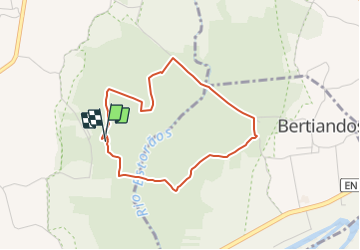
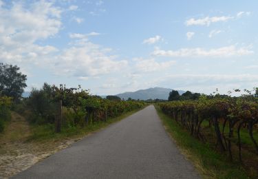
Randonnée A pied de 3,7 km à découvrir à Nord, Viana do Castelo, São Pedro d'Arcos. Cette randonnée est proposée par SityTrail - itinéraires balisés pédestres.
Description
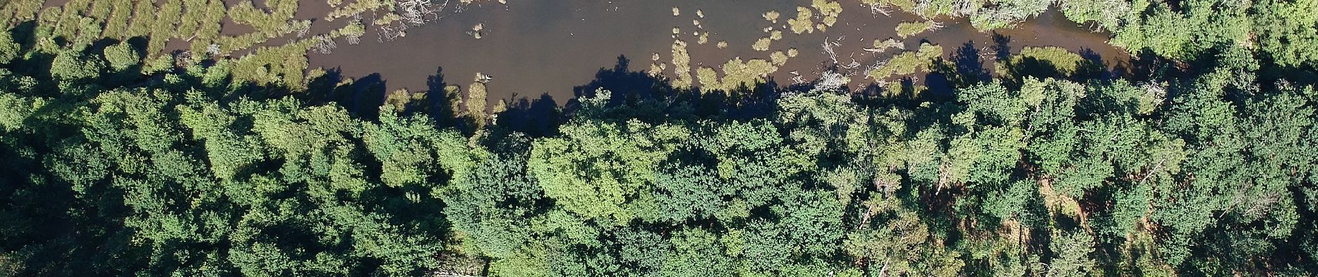
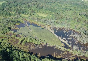
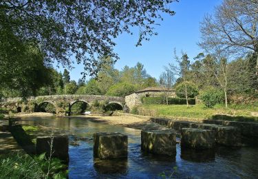
O Percurso das Tapadas é um percurso pedestre denominado de pequena rota. As respetivas marcações e sinalizações obedecem às normas internacionais. O percurso desenvolve-se na Área Protegida das Lagoas de Bertiandos e S. Pedro d?Arcos, permitindo o contacto e interpretação da área das tapadas,...;Nome do Percurso: Percurso das TapadasEntidade Promotora: Município de Ponte de LimaTipo de Percurso: Circular, Pequena RotaÂmbito do Percurso: Ecológico e PaisagísticoPonto de Partida/Chegada: Ponte de Esteiro (Junto ao Campo de Futebol das Lagoas)Distância Percorrida: 3,63 KmDuração do Percurso: 1h45mGrau de Dificuldade: FácilCota Máxima Atingida: 17 metrosPontos de interesse1. Ponte de Esteiro2. Tapadas3. Postos de Observação4. Lago Temporário5. Rio Estorãos6. Centro de Interpretação Ambiental7. Lagoa de S. Pedro d'Arcos8. Moinho de MatiasPonto de partida / chegada41º 45' 52,9'' N | 8º 37' 46,8'' W ;
Site web: https://www.visitepontedelima.pt/pt/turismo/percurso-das-tapadas/
Localisation
Commentaires
Randonnées à proximité
![Randonnée A pied - Trilho do Lobo Atlântico - Photo](https://media.geolcdn.com/t/375/260/5ba811a4-fc38-43d0-b473-94c34ec2d7c8.jpeg&format=jpg&maxdim=2)
![A pied A pied](https://static1.geolcdn.com/sitytour/trail-icons/100.png)
A pied
![](/images/other/stat-length.png)
![](https://static1.geolcdn.com/siteimages/upload/files/16400158638029165_repeat_loop_refresh_sync_direction_icon.png)
![Randonnée A pied Estorãos - Percurso do Cerquido - Photo](https://media.geolcdn.com/t/375/260/b5326e96-b9f3-40e7-b2ce-f3792d9a22c0.jpeg&format=jpg&maxdim=2)
![A pied A pied](https://static1.geolcdn.com/sitytour/trail-icons/100.png)
A pied
![](/images/other/stat-length.png)
![](https://static1.geolcdn.com/siteimages/upload/files/16400158638029165_repeat_loop_refresh_sync_direction_icon.png)
![Randonnée A pied Bertiandos - Rota do Solar - Photo](https://media.geolcdn.com/t/375/260/abe95b11-3636-4be5-b65b-519aa015dcbb.jpeg&format=jpg&maxdim=2)
![A pied A pied](https://static1.geolcdn.com/sitytour/trail-icons/100.png)
A pied
![](/images/other/stat-length.png)
![](https://static1.geolcdn.com/siteimages/upload/files/16400158638029165_repeat_loop_refresh_sync_direction_icon.png)
![Randonnée A pied São Pedro d'Arcos - Percurso da Veiga - Photo](https://media.geolcdn.com/t/375/260/1e3c5b11-5a8f-4ee9-93e7-d75ccf5000ba.jpeg&format=jpg&maxdim=2)
![A pied A pied](https://static1.geolcdn.com/sitytour/trail-icons/100.png)
A pied
![](/images/other/stat-length.png)
![](https://static1.geolcdn.com/siteimages/upload/files/16400158638029165_repeat_loop_refresh_sync_direction_icon.png)
![Randonnée A pied Estorãos - Percurso da Água - Photo](https://media.geolcdn.com/t/375/260/ffe2547d-0da3-40ae-99ba-c29258f17f28.jpeg&format=jpg&maxdim=2)
![A pied A pied](https://static1.geolcdn.com/sitytour/trail-icons/100.png)
A pied
![](/images/other/stat-length.png)
![](https://static1.geolcdn.com/siteimages/upload/files/16400158638029165_repeat_loop_refresh_sync_direction_icon.png)
![Randonnée A pied Estorãos - Rota da Azenha - Photo](https://media.geolcdn.com/t/375/260/c0beb203-4962-49e6-ae66-0755f3c71f4e.jpeg&format=jpg&maxdim=2)
![A pied A pied](https://static1.geolcdn.com/sitytour/trail-icons/100.png)
A pied
![](/images/other/stat-length.png)
![](https://static1.geolcdn.com/siteimages/upload/files/16400158638029165_repeat_loop_refresh_sync_direction_icon.png)
![Randonnée Marche Cabração e Moreira do Lima - Moreira balade - Photo](https://media.geolcdn.com/t/375/260/ext.jpg?maxdim=2&url=https%3A%2F%2Fstatic1.geolcdn.com%2Fsiteimages%2Fupload%2Ffiles%2F1553511878bg_sport_marche.png)
![Marche Marche](https://static1.geolcdn.com/sitytour/trail-icons/101.png)
Marche
![](/images/other/stat-length.png)
![](https://static1.geolcdn.com/siteimages/upload/files/16400158638029165_repeat_loop_refresh_sync_direction_icon.png)
![Randonnée Marche Cabração e Moreira do Lima - Randonnées Valérie - Photo](https://media.geolcdn.com/t/375/260/ext.jpg?maxdim=2&url=https%3A%2F%2Fstatic1.geolcdn.com%2Fsiteimages%2Fupload%2Ffiles%2F1553511878bg_sport_marche.png)
![Marche Marche](https://static1.geolcdn.com/sitytour/trail-icons/101.png)
Marche
![](/images/other/stat-length.png)
![](https://static1.geolcdn.com/siteimages/upload/files/16400158638029165_repeat_loop_refresh_sync_direction_icon.png)
![Randonnée Marche Arca e Ponte de Lima - Chemin Portugais 9 Barcelos - Photo](https://media.geolcdn.com/t/375/260/ext.jpg?maxdim=2&url=https%3A%2F%2Fstatic1.geolcdn.com%2Fsiteimages%2Fupload%2Ffiles%2F1553511878bg_sport_marche.png)
![Marche Marche](https://static1.geolcdn.com/sitytour/trail-icons/101.png)
Marche
![](/images/other/stat-length.png)
![](https://static1.geolcdn.com/siteimages/upload/files/16400158638029165_repeat_loop_refresh_sync_direction_icon.png)